
Farkadona
The ancient Farkadona (Farkadon) was located approximately in the same place as the current village, built on the northern banks of the Pinios. It was a city of the ancient Thessalian state of Estiaiotida and after Trikki it was its second strongest city. The city declined after the conquest of Thessaly by the Macedonians in 357 BC.
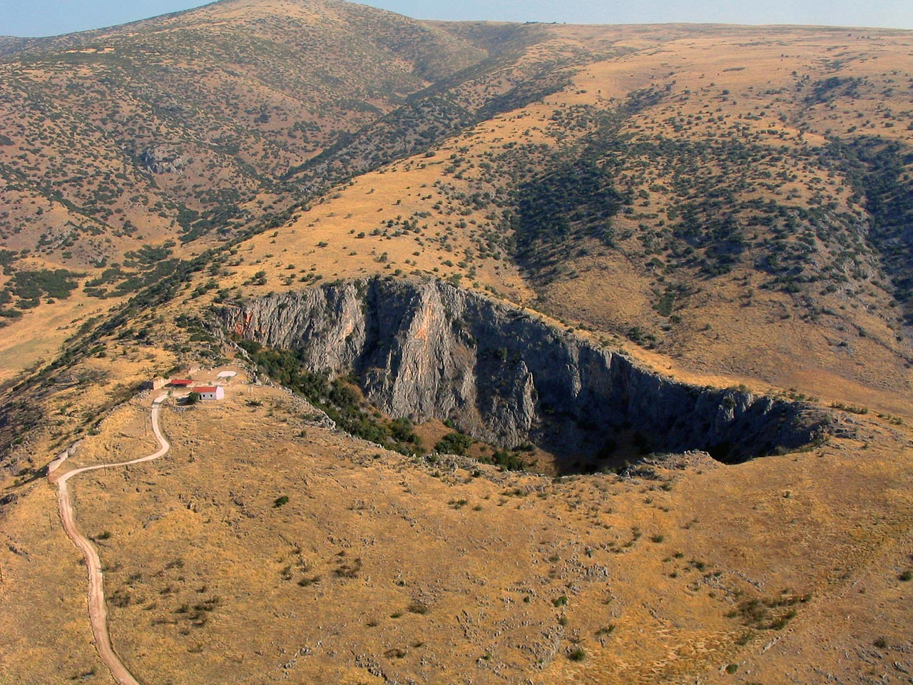
The ancient Farkadona was built near the current community of Klokotos. The city spread over the meridian slopes of the still existing stony hill and together with the cities of Pellina, Gomfoi, Fauto, Mitropolis and Trikki constituted the lowland Estiaotida, one of the 4 tribal states that Thessaly was divided into at the time. The other three states were Pelasgiotida, Phthiotida and Thessaliotida.
The location of Farkadona was originally mentioned by the ancient writer and geographer Strabo, who mentions that the three cities of Estiaiotida Trikki, Pellina and Farkadona were lined up along the left bank of the Pinios river. Based on this information and the testimonies of the ancient writers Arianos, Skylakas, Livy and Pliny, Leake (1835) identified the ruins on the Vigla hill of the community of Klokotos with the ancient Farkadona. It had such a great reputation during its heyday that even the famous Pindar visited it.
It is known that she minted her own coins, a sign of her power, some of which are preserved in the museum of Volos. The surviving coins correspond to three periods, the era of Alexander the Great, the Macedonian era, from 344 to 197, and the period from the time of Flamininus to the time of Diocletian.
The exact time period of the foundation of Farkadona is unknown. Some historians place it on their maps among the most ancient Estiiotian cities, together with Oichali and Phaistos, but this cannot be verified. Important evidence exists only from the period of its destruction (4th century BC).
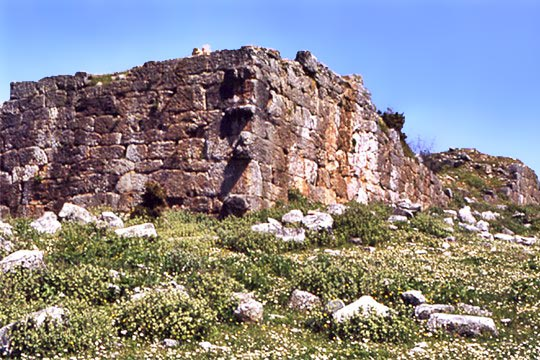
In the year 357 BC Philip II, father of Alexander the Great, tried to interfere in the internal affairs of Thessaly with the ultimate goal of conquering them. He came down with the slogan “liberator” but his plan failed because he found strong resistance from Farkadona and Phauto, as many times as he tried to invade Thessaly from the region of Farkadona.
So he was forced to change tactics. According to the story of Polyaenos, after first capturing Larissa, Philip with his army proceeded to subjugate Farkadona. At the beginning of the siege he encountered strong resistance from the city’s defenders, so he used wooden ladders on the unwalled side of the twin hills which made it easy for his mercenaries to climb the citadel and then capture the entire city.
The Farkadonians never voluntarily allied themselves with the Macedonians. Their minds were always on the revolution. Several attempts were made, but they all drowned in blood.
The men of the army of Farkadona who took part in the Asia Minor Campaign of Alexander the Great were the only ones along with the Trikkaians and Heraklions of Amphissia who were not allowed in the year 323 BC. together with the other veterans to return to their homelands.
A big role in this decision of Alexander was played by his being informed by the Tetrarch of Estiaiotida about the revolutionary dispositions of the Farkadonians who would be more encouraged with the veterans because their power would increase significantly and their attitude towards possible revolutionary action would be stimulated.
Petroto
The village of Petroto until 1955 was called Baya. Then the Greek State, as part of its effort to replace the foreign names of cities and villages with Greek ones, activated the Prefectural Naming Committee, to which the Bayas community proposed three names, of which the Committee preferred the name Petrotos.
The word Baya, according to one view, is of Slavic origin (the Slavs dominated Thessaly after the 8th century AD) and, according to another view, of Albanian origin (the presence of Albanians is mentioned after the 14th century AD). However, either one is valid or the other, it matters little, because in both cases the meaning of the word is about the same and has to do with water. Furthermore, a stream called Kouradiais ran through Baya, and also from the foot of the mountain, during the winter, it gushed out a lot of water. Therefore the name Baya is justified
The area has been inhabited since at least the Bronze Age. An excavation at the “Asvestaria” location, which began as a rescue excavation on the occasion of the construction project of the national highway Larissa – Trikalon, brought to light a settlement of the Late Bronze Age. This find is for western Thessaly the only known case of settlement of the Late Neolithic or even earlier phases.
Among the numerous finds stand out: a) The sections of 14 buildings from the Early Helladic to Late Helladic period. b) 42 burials in box-shaped or pit graves. c) A richly decorated pit tomb of the Roman period, d) The burial of a family (father, mother and infant) in a pit tomb. e) Burial of a mother also in a pit grave who carried the infant at her breast. In a case next to a box-shaped child’s grave, among the other offerings, the skeleton of a dog came to light. f) Many vases of local production, but also several from Argolis and perhaps also from Crete. g) Animal bones under the foundation of a building dated to the Middle Helladic era, between 2134 and 1939 BC, which possibly refer to a foundation ritual as well as the burial of a piglet.
The excavations carried out under the direction of the archaeologist of the Ephorate of Antiquities of Karditsa, Maria Vaiopoulos, with the collaboration of an interdisciplinary team of researchers during a five-year program, provided interesting information about the historical and spatial use of the settlement.
Pelinna
According to mythology, it was founded by Pelinnos, son of Oichalios from Oichalia. It is estimated that Pelinna was inhabited since the Bronze Age, while tombs from the Mycenaean era have also been discovered. During the 5th century BC it came under the influence of Larissa and then Farkadona, however during the Macedonian period from the 4th century to the beginning of the 2nd it prospered due to its pro-Macedonian policy, which it also followed during the Lamia War after the death of Alexander the Great. The perimeter of the acropolis walls is estimated to have been 1,300 meters.
On the coins of the ancient city from the 5th to the 2nd century BC, its name appears as Pelinnaion, and with this name it is also found in the mention of it by the Byzantine historian Stephanus Byzantius (5th century) in his geographical work entitled Nationally.
Oichalia
The city was located on a hill, near the Pelinnaean mountain of Thessaly, and it is possible that there was a theater in the city, based on the archaeological investigations that were carried out and indicate such a thing. Olympians Frikias and Hippokleas, father and son respectively, came from the city.
Neighboring cities in ancient times were Trikki – today’s Trikala – and Farkadona, with Pelinna located between them.
Oichalia refers to the time of Homer around 1200 BC. with its better-known king Eurytos. It is believed to have been destroyed in 1000-800 BC. from the Thessalians.
Later, Niohori appeared, a compound word from the ancient “naus-nios” (ship). + village. So etymologically, Niohori means a place where ships were built, and in fact with wood from Hasia that was transported with the waters of the Kuralios (Neochoritis) river or with the Thessalians horses.
The name Neochori (Neo=Nio) was given wrongly, apparently someone – some took Niochori (Nichori) as Niochori (Nichori). But Niochori means new village and the village was certainly not new. While Niohori means a village where Neas = Ships were built. On the other hand, before the wrong “correction” of H(eta) to I(iota) was made, apparently by some who did not know History, the name of the polychine was NIOHORION. Just as it was mentioned in the Ecclesiastical Codes. With the same name Niochorion also appears on the map which is in Volume I of the book OICHALIA by I. Rizos.
In 542 we find Niohori in the official ecclesiastical codes, which falls under the diocese of Gardiki.
Zarko
In the past, the ancient city of Fayttos was located near the current settlement. In fact, in 1883, during excavations, a marble inscription of 48 BC, 0.72 meters high, was discovered, on which is written a resolution of the city to Gorgias the Gyrtonius.
Also, many archaeological findings from various historical periods have been discovered in Zarkos. In 1957, during the opening of the village’s aqueduct, a clay jar full of golden Macedonian talents with the head of Alexander the Great, dating from around 264 BC, was found in the precincts of the local church. The findings are exhibited at the Archaeological Museum of Volos.
Prehistoric Settlement of Platia Magoula Zarkou
The prehistoric settlement was inhabited from the end of the earliest Neolithic (6500-5800 BC) to the Middle Helladic era (2000-1600 BC). Today it appears in the form of a hill about 5m high. and 200m in diameter.
It can be visited after consultation with the 15th Tax Office of Prehistoric and Classical Antiquities.
Pineiada
Based on an epigraphic find, the ancient city of Atrakos or Atragos (Atrax) is located in the place where today’s Pineiada is located. The exact boundaries of the ancient city are located between Kastri and Pefkia on the Titanos or Dovrutsi rocky mountain. According to mythology, Atrax was Lapithis, son of Pineus and Voura. Administratively, Atrax belonged sometimes to Estiaiotida, sometimes to Pelasgiotida and sometimes to Perraivia.
It flourished in the 5th century BC. – since then it had its own currency – until Roman times and survived during the Byzantine era. In 198 BC repelled the army of the Roman Quintus Flaminius, while in 191 BC. he also successfully resisted the army of Antiochus III of Syria. In 146 BC it was finally submitted to the Romans, who named all the Thessalians Atracians and Atracians.
Today, the archaeological site is crossed by the Pinios river, which by changing its bed towards Atragos has destroyed a part of it, but at the same time it has brought to the surface important finds. Many disasters were also caused by mechanical cultivation.
Στην αρχαιολογική περιοχή του Άτραγος έχουν βρεθεί πολλές αρχαίες επιγραφές (επιτύμβιες, αναθηματικές, ψηφίσματα), οι οποίες εκτός της άλλης σημασίας τους δίνουν πολύτιμα στοιχεία για την αρχαία Θεσσαλική διάλεκτο. Στην περιοχή επίσης υπήρχαν και αρχαία λατομεία. Η ακρόπολη του Άτραγος (αρχαία και βυζαντινά τείχη) σώζεται σε αρκετό μήκος και φαίνεται ότι εκτεινόταν σε περίμετρο 3.000μ. περίπου.